Garden of the Gods Wilderness
Garden of the Gods Wilderness is renowned for its stunning views, unique rock formations, canyons, bluffs, and ridges. Hiking and equestrian trails wind through the area, revealing signs of past human activity, such as homesteads, fruit trees, cemeteries, and abandoned roads. Some of these trails connect the Wilderness to the adjacent Garden of the Gods Observation Site, making it the most visited Wilderness area in Shawnee National Forest. Once home to Indigenous peoples, the area now attracts rock climbers, photographers, and bird-watchers hoping to spot resident raptors. Hiking below the bluffs is easy and tranquil, winding through hardwood trees and moss-covered sandstone.
Description from Wilderness Connect (wilderness.net).
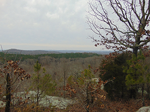
| Designation | Wilderness |
| Managed by | U.S. Forest Service |
| State | Illinois |
| Size | 3,955 acres |
| Designated | 1990, by Congress |
| Center point | 37.60° N, 88.40° W |
| Night sky | About as dark as the ground gets (Black Marble reading 12) |
Boundary map
Boundary, simplified to about 0.005 degrees
The outline is the agency boundary simplified for display, so small parcels and inholdings may not show. The agency page has the authoritative map.
Weather by month
Large units span more than one climate. The station stands in for the center point, and the outer parts of the boundary can be warmer or colder.
Where to camp
No federal campground is within ten miles of the boundary in the Campsite Atlas index. Camping inside a wilderness is usually allowed away from trails and water, with no facilities; the managing agency page has the permit and group-size rules.
Trails
8 named Forest Service trails enter this wilderness, 17 miles in all.
| Trail | Miles | Allowed uses |
|---|---|---|
| New Gog - Karbers Ridge ↗ | 8.3 | |
| R-R Garden of the Gods Loop | 4.4 | |
| Indian Pt Gog | 1.7 | |
| N a Trail | 0.9 | |
| Lower Trail | 0.7 | |
| West Bluff Trail | 0.4 | |
| Anvil Rock Trail | 0.3 | |
| Middle Trail | 0.2 |
Lengths and allowed uses come from the Forest Service trail layer by way of Trailhead Atlas. This trail list was copied from Trailhead Atlas on November 1, 2026 and is copied again on each weekly run. Trails in plain text have no page there yet.
Fire nearby
- PrescribedCretaceous Hills State Natural Area Rx
27 mi from the center point · 48 acres
Distance is to the reported incident point, not the fire edge, and is measured from the center of a boundary that may be many miles across. Check the agency page for closures.
Explore
Nearby on the other atlases
- 6.5 miIllinois Iron Furnace ↗Rosiclare, IL
- 8.6 miCrenshaw House ↗Equality, IL
- 10.5 miRose Hotel ↗Elizabethtown, IL
- 10.8 miSaline County Poor Farm ↗Harrisburg, IL
- 10.9 miHarrisburg City Hall ↗Harrisburg, IL
- 13 miEldorado City Hall ↗Eldorado, IL
- 14.1 miState Bank ↗Old Shawneetown, IL
- 14.2 miPeeples, Robert and John McKee, Houses ↗Old Shawneetown, IL
Landmarks are listed first, then by distance from the boundary.
Guidebooks for Illinois
We earn a small commission if you buy through these links. It does not change what we list.

Titles come from Open Library's catalog, matched by subject heading or by title.
Reference
Questions people ask
How big is Garden of the Gods Wilderness?
3,955 acres.
Source: Wilderness Connect
Who manages Garden of the Gods Wilderness?
The U.S. Forest Service.
Source: Wilderness Connect
What state is Garden of the Gods Wilderness in?
Illinois.
Source: Wilderness Connect
When was Garden of the Gods Wilderness designated?
Congress designated it in 1990.
Source: Wilderness Connect
How do I get to Garden of the Gods Wilderness?
A point inside the boundary is at 37.603° N, 88.397° W. The official page carries directions and the office address.
Source: Wilderness Connect
Is there a fire near Garden of the Gods Wilderness right now?
1 active incident within 50 miles as of 2026-11-01, the nearest Cretaceous Hills State Natural Area Rx at 27 miles. Distance is to the reported incident point, not the fire edge.
Source: Fire nearby
Are there historic places near Garden of the Gods Wilderness?
The National Register has 9 listings within 15 miles, including Illinois Iron Furnace and Crenshaw House.
Source: Register Atlas
Sources
- Boundary, name, acreage, designation year, states and description: Wilderness Connect.
- Campgrounds: the Campsite Atlas index of federal campgrounds, matched to this boundary at build time.
- Trailheads and sites: the Forest Service Recreation Opportunities layer, points inside the boundary.
- Trails: the Trailhead Atlas open-data file of Forest Service trails, matched on the wilderness each trail enters.
- Night sky: NASA Black Marble (VIIRS, 2016 composite) sampled at zoom 6 around the center point.
- Weather, alerts, air quality, river flow and earthquakes load live in your browser from NWS, AirNow, USGS and iNaturalist when you open the page.